Isthmus of Panama
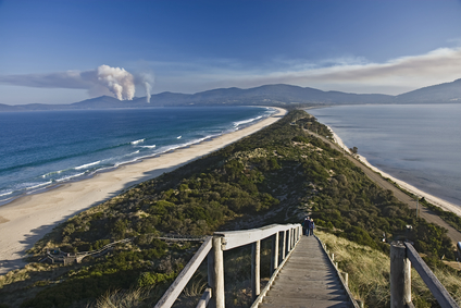
The Isthmus picture above is of one land mass to the next.
An isthmus is a strip of narrow land with water on each side, connecting two greater land masses.
An isthmus can be formed by volcanic activity, creating a chain of islands that block a channel and collect sediment, forming an isthmus. This is how the Isthmus of Panama was formed. A drop in sea level can form an isthmus as more land is exposed above the water.
An isthmus may be only a few miles wide, or in some cases much more. The Isthmus of Tehuantepec separates the Gulf of Mexico from the Pacific Ocean by 119 miles at its narrowest point.
An isthmus can be found where two land masses join through a narrow portion of land.
• Isthmus of Panama
• Isthmus of Suez, Egypt
• Isthmus of Perekop, Ukraine
• Isthmus of Cap Cod, Massachusetts, USA
The Isthmus of Panama is a narrow strip of land, 30 miles wide at its narrowest point, joining the North and South American Continents. It was formed approximately 3 million years ago, dividing the waters of the Caribbean Sea on one side and the Pacific Ocean on the other.
This created enormous changes in ocean currents and wind patterns, increasing temperatures in the North Atlantic and Europe. The Panama Canal was completed across the isthmus in 1914, connecting the two bodies of water for shipping and passengers.
The Isthmus of Suez in Egypt is 75 miles wide and connects the African and Asian continents, separating the Meditarranean Sea and Red Sea. The Suez Canal was completed in 1869, linking these two bodies of water and providing passage to the Indian Ocean.
The Isthmus of Perekop is only 3 miles wide at one point and links the Ukrainian mainland to the Crimean Peninsula. Like the Isthmus of Suez, it has been an historically critical strategic point in order to control passage through the isthmus and the land beyond.
The Isthmus of Cape Cod on the east coast of Massachusetts is 4 1/2 miles wide at its narrowest point. The Cape Cod Canal was built just south of here and is 7 miles long.
A narrow portion of land with water on each side, connecting two larger land areas
We want pictures and location of the lanforms around the world and we need your help. Click get started button below.

In Asia, China, India, Nepal, and Bhutan are home to one of the eight wonders of the world and one of the most beautiful mountains in the world, the Himalaya Mountains also called the Himalayas. Boasting as the world’s highest and most famous mountain peak, Mt. Everest. Within the verse of the ‘Kumarsambhava’, Sanskrit […]

Nature have provided us with fascinating landforms and features. The most often adored landforms are volcanoes. Like the perfect cone structure of Mayon Volcano in the Philippines or Mount Fiji in Japan, people look at their beauty and wonder with great appreciation to nature. Volcanoes are mountains with a very disastrous nature. Their only […]

Taal Volcano is the second most active volcano found in the province of Batangas. A complex volcano in the middle of Taal Lake and is often called an island within a lake, that is an island within a lake that is on an island as well as one of the lowest volcano in the […]

Mayon Volcano is one of the active volcanoes in the Philippines. Located in the southern part of Luzon about 473 kilometers (294 miles) from Makati Business District of the Philippines, Mount Mayon is the main landmark of the Province of Albay of Bicol Region. According to local folklore, the volcano was named after Daragang […]

The global temperature and weather is to a large extent a direct result of the sun’s effect to our planet. Together with the atmosphere and the rotation of the earth on its axis. The earth on which weather moves on has its own effect on the weather. The different landforms like mountains, volcanoes, plains, and the […]

