Mt. St. Helens, Washington State, USA
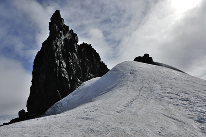
The lava spine picture above is at the summit of Snaefellsjokull, a Volcano in Iceland
A lava spine is magma in solid form, rising from a lava dome. It may be in the form of a column, or a slab or other shape.
When magma within a lava dome has cooled enough to maintain its shape, pressure from a vent below can force the solid portion upward and out of the dome. A spine can also rise directly from a vent.
A lava spine can be from a few feet wide to hundreds of feet across and hundreds of feet high.
A lava spine can be found in an active lava dome or vent that may be inside a volcanic crater, or in an area of volcanic activity.
• Mt. St. Helens, Washington State, USA
• Mt. Pelée, Island of Martinique, Antilles Islands
• Mt. Sinabung, northern Sumatra
After the 1980 catastrophic eruption of Mt. St. Helens, a lava dome soon began to grow from the inside the large mountain crater. In February 1983, one spine was seen rising out of the dome, which then collapsed. A second spine called the “Whaleback” soon began rising and remained until July, 2005 before collapsing.
In 2006, another spine in the form of a slab, described as half the size of a football field, began rising from the dome. The major portion of this remained until October when a large collapse and avalanche occurred at the dome. After an eruption that killed 30,000 people, Mt. Pelée on the Island of Martinique began to produce a spine from a vent in the crater floor in October, 1902.
The spine rose to a height of approximately 1000 feet, measuring from 300 to 500 feet wide before collapsing in March, 1903. Renewed activity at Mt. Pelée in 1929 produced another spine of smaller size. In northern Sumatra on August 29, 2010, Mt. Sinabung began to erupt several times, continuing in early September.
Ash plumes were sent upward and lava overflowed the crater at one point. After the largest eruption on September 7, activity continued and slowed during the following weeks, and a spine rose slowly out of the lava dome in the crater.
Magma in solid form rising from a lava dome or vent usually in a vertical shape.
We want pictures and location of the lanforms around the world and we need your help. Click get started button below.

In Asia, China, India, Nepal, and Bhutan are home to one of the eight wonders of the world and one of the most beautiful mountains in the world, the Himalaya Mountains also called the Himalayas. Boasting as the world’s highest and most famous mountain peak, Mt. Everest. Within the verse of the ‘Kumarsambhava’, Sanskrit […]

Nature have provided us with fascinating landforms and features. The most often adored landforms are volcanoes. Like the perfect cone structure of Mayon Volcano in the Philippines or Mount Fiji in Japan, people look at their beauty and wonder with great appreciation to nature. Volcanoes are mountains with a very disastrous nature. Their only […]

Taal Volcano is the second most active volcano found in the province of Batangas. A complex volcano in the middle of Taal Lake and is often called an island within a lake, that is an island within a lake that is on an island as well as one of the lowest volcano in the […]

Mayon Volcano is one of the active volcanoes in the Philippines. Located in the southern part of Luzon about 473 kilometers (294 miles) from Makati Business District of the Philippines, Mount Mayon is the main landmark of the Province of Albay of Bicol Region. According to local folklore, the volcano was named after Daragang […]

The global temperature and weather is to a large extent a direct result of the sun’s effect to our planet. Together with the atmosphere and the rotation of the earth on its axis. The earth on which weather moves on has its own effect on the weather. The different landforms like mountains, volcanoes, plains, and the […]

