Example of a Lava Tube Landform:
Lava Beds National Monument, California, USA
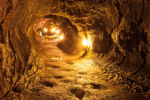
The lava tube picture is of the Thurston Lava Tube in Hawaii Volcano National Park at the Big Island.
A lava tube is a flow of lava that has solidified, having a hollow area inside.
A flow of lava solidifies on the outer surface and the molten lava inside drains away, leaving a hollow space. Basaltic lava or another form of very fluid lava is necessary.
A lava tube can be less than three feet wide, or large enough to form a cave of up to 50 feet wide. Some lava tubes can extend for miles.
Lava tubes can be found in areas of current and former volcanic activity.
• Lava Beds National Monument, California, USA
• Mauna Loa, Hawaii, USA
• Kazumura Cave, Mt. Kilauea, Hawaii, USA
• Monte Corona, Island of Lanzarote, Canary Islands
• Cueva del Viento-Sobrado on the island of Tenerife in Spain
Lava Beds National Monument is found on a portion of Medicine Lake Volcano in northeastern California. The volcano is no longer active and there are many large lava tubes as caves that visitors can explore. A lava tube formed in 1859 by Mauna Loa on the Island of Hawaii runs 31 miles before entering the ocean.
The Kazumura Cave begins at Mt. Kilauea, also on the Island of Hawaii, a lava tube that was formed 500 years ago. The cave continues for 40 miles at a depth of up to 3600 feet as the longest, deepest lava tube known. A 3000 year old cave was formed by a lava tube at the volcano of Monte Corona in the Canary Islands. It runs for almost 5 miles, finishing the last mile below the sea.
A large area of the cave near the entrance is used as a concert hall, permitting up to 500 people to hear a performance. Europe’s largest lava tube formation is the Cueva del Viento-Sobrado on the island of Tenerife in Spain. It includes over 10 miles of passages at three different levels, with many visible fossils that include animals no longer living today. It also served as a hideout for bandits in the 10th century.
A flow of lava that has a solid outer surface and is hollow
We want pictures and location of the lanforms around the world and we need your help. Click get started button below.

In Asia, China, India, Nepal, and Bhutan are home to one of the eight wonders of the world and one of the most beautiful mountains in the world, the Himalaya Mountains also called the Himalayas. Boasting as the world’s highest and most famous mountain peak, Mt. Everest. Within the verse of the ‘Kumarsambhava’, Sanskrit […]

Nature have provided us with fascinating landforms and features. The most often adored landforms are volcanoes. Like the perfect cone structure of Mayon Volcano in the Philippines or Mount Fiji in Japan, people look at their beauty and wonder with great appreciation to nature. Volcanoes are mountains with a very disastrous nature. Their only […]

Taal Volcano is the second most active volcano found in the province of Batangas. A complex volcano in the middle of Taal Lake and is often called an island within a lake, that is an island within a lake that is on an island as well as one of the lowest volcano in the […]

Mayon Volcano is one of the active volcanoes in the Philippines. Located in the southern part of Luzon about 473 kilometers (294 miles) from Makati Business District of the Philippines, Mount Mayon is the main landmark of the Province of Albay of Bicol Region. According to local folklore, the volcano was named after Daragang […]

The global temperature and weather is to a large extent a direct result of the sun’s effect to our planet. Together with the atmosphere and the rotation of the earth on its axis. The earth on which weather moves on has its own effect on the weather. The different landforms like mountains, volcanoes, plains, and the […]

