Example of a Ravine Landform:
Sages Ravine, Connecticut, USA
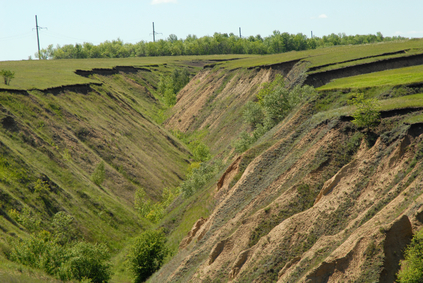
The ravine picture is in the middle of a farm field.
A ravine is similar to a canyon or a valley with steep sides, but smaller.
A ravine is usually larger than a gully. A ravine may have an active stream year around or during the wet season. Some ravines remain dry due to a change of climate since it was formed.
Ravines are formed by the action of a stream that erodes the land.
A ravine is generally several hundred feet wide.
Ravines are found in mountain regions and lower elevations that have hills and changing land features.
• Sages Ravine, Connecticut, USA
• Rosedale Ravine, Toronto, Ontario, Canada
• Edgemont Ravine, Calgary, Alberta, Canada
• Tuckerman Ravine, Mt. Washington, New Hampshire, USA
Sages Ravine is a popular scenic hiking area at the western end of the border between Connecticut and Massachusetts. Many trails give different levels of challenge for hikers, including one that takes you to the top of Bear Mountain for spectacular scenic views of the area.
In the center of the city of Toronto, Rosedale Ravine provides an escape from the rush of people and traffic. In just a moment, you can leave behind the city noise and step down into the ravine and walk beneath trees that are over 150 years old.
A creek runs through the forest which is maintained by the city to protect the native plants and trees that have survived in the middle of an urban area. Edgemont Ravine, a group of several connected ravines, is another natural area of land that has been maintained as part of a city environment.
Located in the middle of Edgemont, a residential suburb of the city of Calgary, it includes a wetland that was developed to support waterfowl and other small animals. Tuckerman Ravine is found on Mt. Washington in New Hampshire and is a popular ski area.
The head of the ravine is a bowl shaped side of the mountain with various runs taken by skiers. There are no lifts or other facilities, so that skiers must hike up to the top in order to ski down the slopes. The mountain is also known for high winds at times and a danger of snow avalanches in the ravine.
Ravine Definition:
A smaller version of a valley with steep sides.
We want pictures and location of the lanforms around the world and we need your help. Click get started button below.

In Asia, China, India, Nepal, and Bhutan are home to one of the eight wonders of the world and one of the most beautiful mountains in the world, the Himalaya Mountains also called the Himalayas. Boasting as the world’s highest and most famous mountain peak, Mt. Everest. Within the verse of the ‘Kumarsambhava’, Sanskrit […]

Nature have provided us with fascinating landforms and features. The most often adored landforms are volcanoes. Like the perfect cone structure of Mayon Volcano in the Philippines or Mount Fiji in Japan, people look at their beauty and wonder with great appreciation to nature. Volcanoes are mountains with a very disastrous nature. Their only […]

Taal Volcano is the second most active volcano found in the province of Batangas. A complex volcano in the middle of Taal Lake and is often called an island within a lake, that is an island within a lake that is on an island as well as one of the lowest volcano in the […]

Mayon Volcano is one of the active volcanoes in the Philippines. Located in the southern part of Luzon about 473 kilometers (294 miles) from Makati Business District of the Philippines, Mount Mayon is the main landmark of the Province of Albay of Bicol Region. According to local folklore, the volcano was named after Daragang […]

The global temperature and weather is to a large extent a direct result of the sun’s effect to our planet. Together with the atmosphere and the rotation of the earth on its axis. The earth on which weather moves on has its own effect on the weather. The different landforms like mountains, volcanoes, plains, and the […]

