Example of a Rift Valley Landform:
East Rift Valley, Taiwan
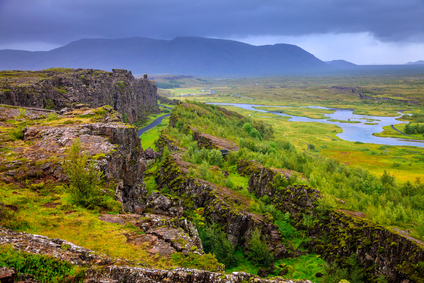
The rift valley picture above is of Thingvellir National Park located in Iceland. The North American and Eurasian tectonic plates separate at this location.
A rift valley is a valley or depression in the land bordered by fault zones and separating tectonic plates.
The depressed areas of a rift valley are formed by one or more grabens. A graben is a fallen portion of land with faults on 2 or more sides. When outer landmasses move away from the fault zones, the land in the middle can slowly drop during a period of thousands of years. This forms a lower portion of land called a graben. A graben may continue to drop and become the floor of a rift valley.
A rift valley may be from a few hundred feet wide to many miles across. The depression in the Great Rift Valley of East Africa is up to 37 miles wide.
Rift valleys can be found in areas that have faults in the Earth´s crust where separation of land masses has occurred. Rift valleys also occur on the ocean floor at mid-ocean ridges where the seafloor separates between tectonic plates.
• East Rift Valley, Taiwan
• Jordan Rift Valley, Israel and Jordan
• Baikal Rift Valley, southern Siberia
• Great Rift Valley, East Africa
The East Rift Valley in Taiwan runs along the east side of the Island near the seacoast. It lies east of the Central Mountain Range that dominates the island. The Eurasian tectonic plate lies on one side and the Philippine plate on the other side of the rift valley. They have slowly moved apart and the rift valley has dropped.
The region has been designated a National Scenic Area, attracting many tourists to see the rivers, trails, waterfalls, mountains and canyons in the area. The Jordan Rift Valley extends across the Israel-Jordan border and includes the Dead Sea, having the lowest elevation of any land area in the world at 1,237 feet below sea level.
The Baikal Rift Valley in southern Siberia is deeper than any other continental rift valley. Lake Baikal fills the valley and is the deepest freshwater lake in the world at 3,893 feet. Almost 400 miles long, it is also the largest freshwater lake by volume of water.
The East African Rift, also called the Great Rift Valley in East Africa, is the largest continental rift valley on Earth, stretching for about 3000 miles north and south and reaching up to 37 miles wide. The deepest portion is 6,000 feet below the surrounding area. As the tectonic plates on each side continue to move apart, during the next 10 million years the East African Rift is expected to separate and form an ocean basin. Land east of the rift will then become a large island off the African coast.
A rift valley is separating of land masses causing the ground to sink forming a valley.
We want pictures and location of the lanforms around the world and we need your help. Click get started button below.

In Asia, China, India, Nepal, and Bhutan are home to one of the eight wonders of the world and one of the most beautiful mountains in the world, the Himalaya Mountains also called the Himalayas. Boasting as the world’s highest and most famous mountain peak, Mt. Everest. Within the verse of the ‘Kumarsambhava’, Sanskrit […]

Nature have provided us with fascinating landforms and features. The most often adored landforms are volcanoes. Like the perfect cone structure of Mayon Volcano in the Philippines or Mount Fiji in Japan, people look at their beauty and wonder with great appreciation to nature. Volcanoes are mountains with a very disastrous nature. Their only […]

Taal Volcano is the second most active volcano found in the province of Batangas. A complex volcano in the middle of Taal Lake and is often called an island within a lake, that is an island within a lake that is on an island as well as one of the lowest volcano in the […]

Mayon Volcano is one of the active volcanoes in the Philippines. Located in the southern part of Luzon about 473 kilometers (294 miles) from Makati Business District of the Philippines, Mount Mayon is the main landmark of the Province of Albay of Bicol Region. According to local folklore, the volcano was named after Daragang […]

The global temperature and weather is to a large extent a direct result of the sun’s effect to our planet. Together with the atmosphere and the rotation of the earth on its axis. The earth on which weather moves on has its own effect on the weather. The different landforms like mountains, volcanoes, plains, and the […]

