Example of a Sinkhole Landform:
Xiaozhai Tiankeng, Chongqing Municipality, China
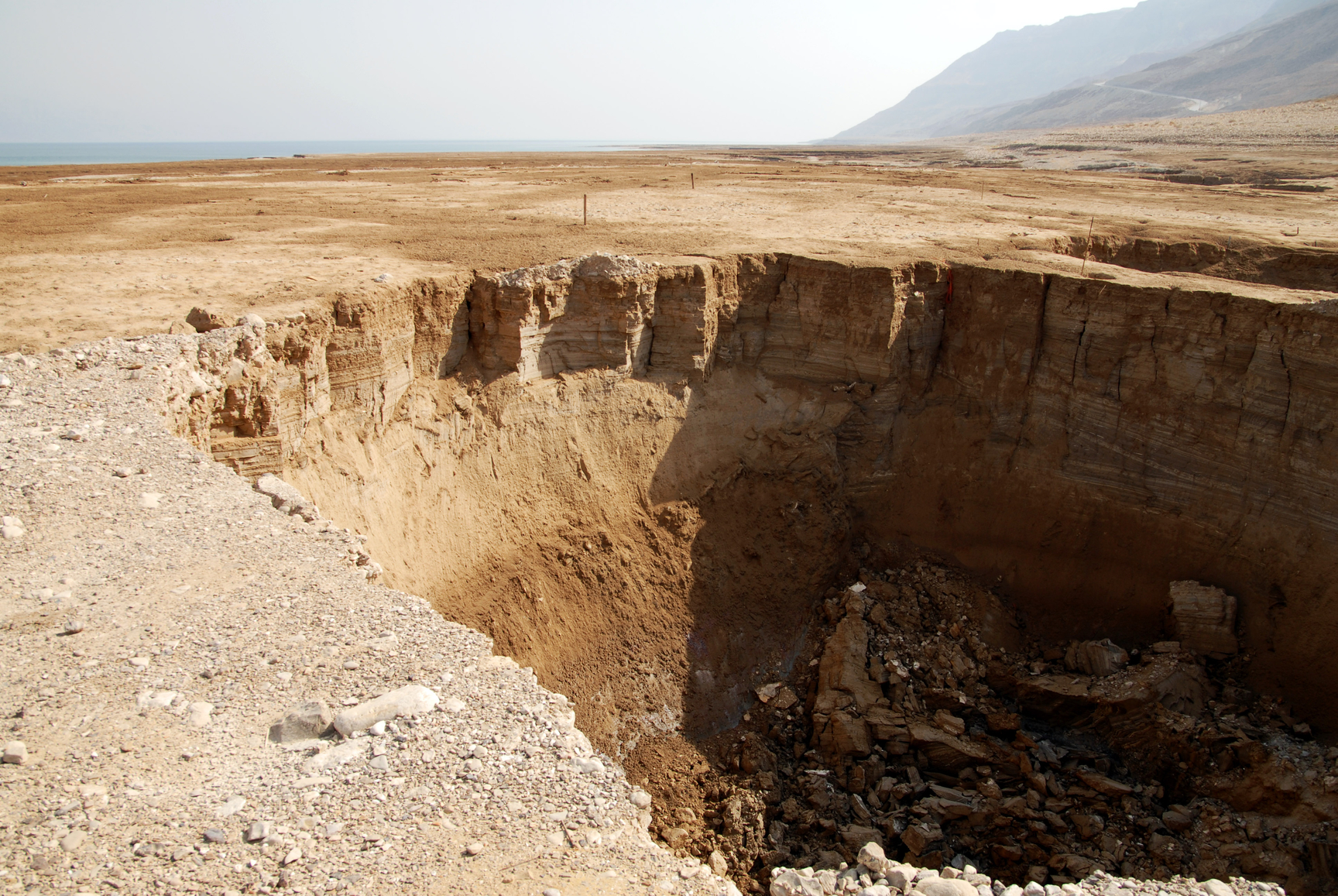
The sinkhole picture is of the Dead Sea in Israel.
A sinkhole is a hole in the ground caused by the collapse of underground soft rock formations.
Sinkholes are usually caused by moving groundwater below the surface that dissolves limestone or other soft rock formations, causing them to collapse and form a hole in the ground.
Sinkholes have been found that are from 3 feet across to over 2000 feet in diameter.
Sinkholes can be found where underground limestone or other soft rock formations exist and there is substantial ground water movement.
Cenotes are sinkholes in an area where the water table is very high, so that groundwater is visible in the hole, sometimes forming a lake or pool near the surface.
• Xiaozhai Tiankeng, Chongqing Municipality, China
• Zacatón, Tamaulipas, Mexico
• Sima de las Cotorras, Chiapas, Mexico
The world’s deepest known sinkhole is called Xiaozhai Tiankeng and is located in the Chongqing Municipality of southwest China. It is 2151 feet deep and more than 2000 feet across at the surface. Well known to local people, it was discovered by researchers in 1994.
El Zacatón is located in the Aldama Municipality in Tamaulipas, Mexico and is the world’s deepest known water filled sinkhole, measuring 1112 feet deep. The water begins 66 feet down from the ground’s surface. The name refers to floating islands of zacate grass on the surface of the water.
Sima de las Cotorras is a very large sinkhole 520 feet wide and 460 feet deep and is known for having thousands of green parakeets that live in the trees that grow at the bottom of the hole. There are also 80 other species of birds and hummingbirds living among them. About half way down on the sides of the hole there are ancient paintings estimated to be from 5,000 to 10,000 years old.
A hole in the ground that was created by the collapse of limestone or other soft rock formations below the surface.
We want pictures and location of the lanforms around the world and we need your help. Click get started button below.

In Asia, China, India, Nepal, and Bhutan are home to one of the eight wonders of the world and one of the most beautiful mountains in the world, the Himalaya Mountains also called the Himalayas. Boasting as the world’s highest and most famous mountain peak, Mt. Everest. Within the verse of the ‘Kumarsambhava’, Sanskrit […]

Nature have provided us with fascinating landforms and features. The most often adored landforms are volcanoes. Like the perfect cone structure of Mayon Volcano in the Philippines or Mount Fiji in Japan, people look at their beauty and wonder with great appreciation to nature. Volcanoes are mountains with a very disastrous nature. Their only […]

Taal Volcano is the second most active volcano found in the province of Batangas. A complex volcano in the middle of Taal Lake and is often called an island within a lake, that is an island within a lake that is on an island as well as one of the lowest volcano in the […]

Mayon Volcano is one of the active volcanoes in the Philippines. Located in the southern part of Luzon about 473 kilometers (294 miles) from Makati Business District of the Philippines, Mount Mayon is the main landmark of the Province of Albay of Bicol Region. According to local folklore, the volcano was named after Daragang […]

The global temperature and weather is to a large extent a direct result of the sun’s effect to our planet. Together with the atmosphere and the rotation of the earth on its axis. The earth on which weather moves on has its own effect on the weather. The different landforms like mountains, volcanoes, plains, and the […]

