Blowout Landforms Have 2 Main Characteristics:
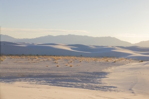
White Sands National Monument, New Mexico
A blowout is a depression in the ground where the topsoil or sand has been carried away by the wind.
A blowout can be a few feet wide or bigger, and are commonly under 50 feet in diameter. The depth of a blowout may be from a few inches to several feet. In unusual cases, they have grown to several kilometers wide and over 200 feet deep.
If plant growth is eliminated for any reason, and the soil is sandy or loose, wind can blow it away and create a depression in the ground. After a grass fire, sandy or loose topsoil can be blown away. Naturally caused and man-made fires can cause blowouts, if the soil is loose and exposed to the wind.
Other factors that can contribute to blowouts are too much human activity or poor agricultural practices, allowing loose soil to be exposed to the wind. Improper management of herd animals over loose or sandy soil can cause soil to be carried away by winds.
Poor land management during mining operations can cause blowouts in some circumstances. In certain areas, recreational activities with bicycles, motorcycles, ATV’s and other 4 wheel drive vehicles can destroy plant cover and expose loose soil to the wind, causing blowouts.
Blowouts occur more often near the seashore where strong winds are frequent and little protection exists to block the wind. Many beach areas have sand dunes behind them where plant growth has established a root system to help stabilize the ground.
When a portion of this vegetation has been removed, the sand underneath can be exposed, permitting strong winds to open up the ground and pull sand from underneath the surrounding area. A large blowout can develop from a small area that lacks vegetation. At the Ravenmeols Local Nature Reserve in Merseyside, UK, a large blowout has occurred in this way which they now call the Devil’s Hole.
A depression or a major loss in vegetation in the ground where the wind has blown away sand or topsoil.
Related: Beaches, Desert, Basin
We want pictures and location of the lanforms around the world and we need your help. Click get started button below.
In Asia, China, India, Nepal, and Bhutan are home to one of the eight wonders of the world and one of the most beautiful mountains in the world, the Himalaya Mountains also called the Himalayas. Boasting as the world’s highest and most famous mountain peak, Mt. Everest. Within the verse of the ‘Kumarsambhava’, Sanskrit […]
Nature have provided us with fascinating landforms and features. The most often adored landforms are volcanoes. Like the perfect cone structure of Mayon Volcano in the Philippines or Mount Fiji in Japan, people look at their beauty and wonder with great appreciation to nature. Volcanoes are mountains with a very disastrous nature. Their only […]
Taal Volcano is the second most active volcano found in the province of Batangas. A complex volcano in the middle of Taal Lake and is often called an island within a lake, that is an island within a lake that is on an island as well as one of the lowest volcano in the […]
Mayon Volcano is one of the active volcanoes in the Philippines. Located in the southern part of Luzon about 473 kilometers (294 miles) from Makati Business District of the Philippines, Mount Mayon is the main landmark of the Province of Albay of Bicol Region. According to local folklore, the volcano was named after Daragang […]
The global temperature and weather is to a large extent a direct result of the sun’s effect to our planet. Together with the atmosphere and the rotation of the earth on its axis. The earth on which weather moves on has its own effect on the weather. The different landforms like mountains, volcanoes, plains, and the […]