The Brahmaputra and Jamuna Rivers in Bangladesh
The picture above is an example of a braided river in Spain, the Sella River.
A river that has multiple channels flowing downstream is a braided river. These channels may return to the river, or drain into a common body of water.
Braided river formations are common where water flow is slow and there is a build up of sediment in the river. This can cause changes in the direction of the river and create new channels. This can occur to form a river delta, which is a form of braided river.
They can be found in areas where the land is very flat and the river moves slowly. There is usually a buildup of sediment. The water may be shallow with a history of changing its path. Sometimes instead of changing direction, another channel may be formed. Faster moving waters may also create new channels when there is a buildup of sediment in a portion of the river.
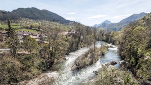
The Platte River, Nebraska
The Brahmaputra and Jamuna Rivers in Bangladesh
Yellow River in China
The Platte River in Nebraska is a slow and shallow river that has multiple channels in some areas, creating many islands. Traveling by boat is difficult in many parts of the river. In the region where the Brahmaputra and Jamuna Rivers meet in Bangladesh, there is a braided river system draining into Bengal Bay of the Indian Ocean.
The Brahmaputra and Jamuna rivers are known to change their path as they flow over the land, which can sometimes cause flooding and loss of life and property. The Brahmaputra River is unusual for having a tidal bore, a wave that travels upstream for many miles during the rising tide.
The Yellow River (Huang He) in China is considered to be the cradle of Chinese civilization. It has also been responsible for much loss of life during its history as it changes course, sometimes causing catastrophic flooding. Course changes and the channels of its braided river system are caused by sediment that comes down from the mountains, raising the level of the river. The sediment is created from erosion that occurs in the mountains, some of which is man-made.
A river that has 3 or more channels that may come together again, or drain into the same body of water
See Also: River and
We want pictures and location of the lanforms around the world and we need your help. Click get started button below.

In Asia, China, India, Nepal, and Bhutan are home to one of the eight wonders of the world and one of the most beautiful mountains in the world, the Himalaya Mountains also called the Himalayas. Boasting as the world’s highest and most famous mountain peak, Mt. Everest. Within the verse of the ‘Kumarsambhava’, Sanskrit […]

Nature have provided us with fascinating landforms and features. The most often adored landforms are volcanoes. Like the perfect cone structure of Mayon Volcano in the Philippines or Mount Fiji in Japan, people look at their beauty and wonder with great appreciation to nature. Volcanoes are mountains with a very disastrous nature. Their only […]

Taal Volcano is the second most active volcano found in the province of Batangas. A complex volcano in the middle of Taal Lake and is often called an island within a lake, that is an island within a lake that is on an island as well as one of the lowest volcano in the […]

Mayon Volcano is one of the active volcanoes in the Philippines. Located in the southern part of Luzon about 473 kilometers (294 miles) from Makati Business District of the Philippines, Mount Mayon is the main landmark of the Province of Albay of Bicol Region. According to local folklore, the volcano was named after Daragang […]

The global temperature and weather is to a large extent a direct result of the sun’s effect to our planet. Together with the atmosphere and the rotation of the earth on its axis. The earth on which weather moves on has its own effect on the weather. The different landforms like mountains, volcanoes, plains, and the […]

