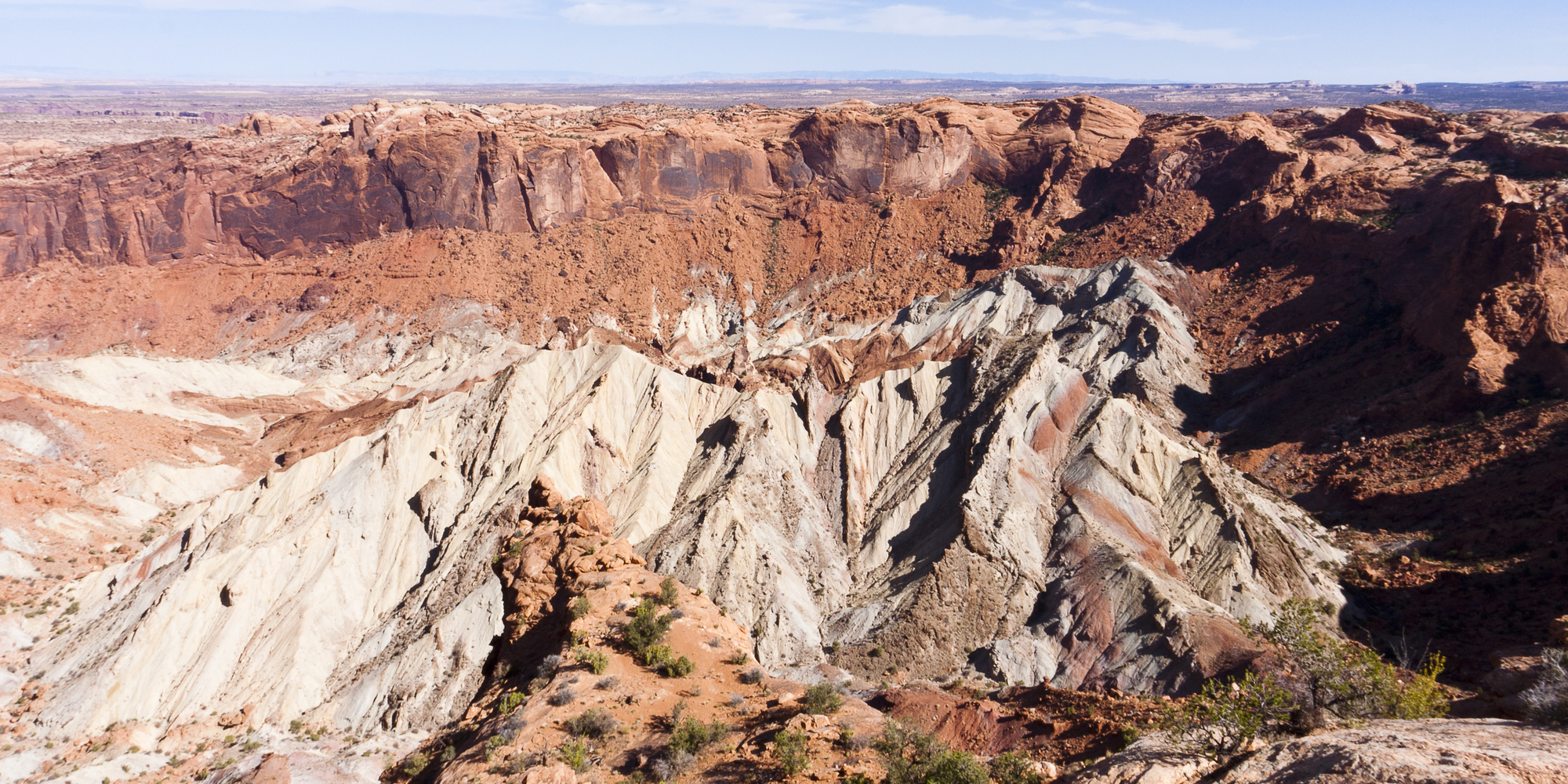
The dome picture above is of Upheaval Dome , Canyonlands National Park, Utah, USA
A dome is a round or oval-shaped formation that has risen above the ground around it.
A dome can sometimes be formed by the impact of a meteor. This can break up the layers of rock under the ground, so that pressure and the weight of the ground and rock layers nearby can push the area upward. The broken layers of rock have less resistance to underground pressure and the land may lift upward to form a dome shape. This may take thousands of years to occur after an impact.
Another way that a dome is formed is by geological stress that cause folding of the land. This folding can take place from different directions at different times. When folds of land run in different directions, this can cause an uplift of the land where they meet to form a dome-like area.
Still another way a dorm can be formed is when there is a difference in the density of material underground. If there is an area that contains material that is less dense or lighter than the rock and ground around it, this can cause the material to rise. The weight of the heavier rock around the material can force it upward, and it may push the ground layers above it upward to form a dome. This may take many thousands of years to occur.
A dome can be less than 100 feet in diameter or several miles wide. One of the largest was 44 miles wide, formed after a meteor impact.
At some meteor impact sites, a dome can be found. In areas where folding of the land has occurred with long hills that cross and intersect, a dome formation may be present.
• Upheaval Dome , Canyonlands National Park, Utah, USA
• Richat Structure near Ouadane, Mauritania
• Vredefort Crater , Vredefort, South Africa
Southwest of Moab, Utah in Canyonlands National Park can be found a dome inside a crater that was formed by a meteor impact. Much of the crater has eroded away. The dome is 3 miles in diameter and the crater is estimated to be 170 million years old.
The Richat Structure or “Eye of the Sahara” lies in the Sahara Desert of northern Africa in the country of Mauritania. Once thought to be formed after a meteor impact, research now indicates the 25 mile diameter dome may have been caused by geological forces in the land.
The largest known impact crater on Earth encircles Vredefort, South Africa and was more than 180 miles in diameter when visible. A 44 mile wide dome formed in the center where the impact occurred about 2 billion years ago. Only portions of the dome remain.
A round or oval formation in the land, elevated above the ground around it
We want pictures and location of the lanforms around the world and we need your help. Click get started button below.

In Asia, China, India, Nepal, and Bhutan are home to one of the eight wonders of the world and one of the most beautiful mountains in the world, the Himalaya Mountains also called the Himalayas. Boasting as the world’s highest and most famous mountain peak, Mt. Everest. Within the verse of the ‘Kumarsambhava’, Sanskrit […]

Nature have provided us with fascinating landforms and features. The most often adored landforms are volcanoes. Like the perfect cone structure of Mayon Volcano in the Philippines or Mount Fiji in Japan, people look at their beauty and wonder with great appreciation to nature. Volcanoes are mountains with a very disastrous nature. Their only […]

Taal Volcano is the second most active volcano found in the province of Batangas. A complex volcano in the middle of Taal Lake and is often called an island within a lake, that is an island within a lake that is on an island as well as one of the lowest volcano in the […]

Mayon Volcano is one of the active volcanoes in the Philippines. Located in the southern part of Luzon about 473 kilometers (294 miles) from Makati Business District of the Philippines, Mount Mayon is the main landmark of the Province of Albay of Bicol Region. According to local folklore, the volcano was named after Daragang […]

The global temperature and weather is to a large extent a direct result of the sun’s effect to our planet. Together with the atmosphere and the rotation of the earth on its axis. The earth on which weather moves on has its own effect on the weather. The different landforms like mountains, volcanoes, plains, and the […]

