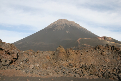
Mount Elden near Flagstaff, Arizona, USA
The lava dome picture is an example.
A lava dome is a hill-shaped formation created by lava flows.
Lava escapes from one or more openings in the ground to form a lava dome.This can occur repeatedly at the same location to grow a lava dome during a period of days, months or years.
A lava dome can range from a few feet in height to the size of a mountain peak.
Lava domes can be found in areas of volcanic activity. They often form inside the crater of an active volcano. A volcano can also be a lava dome. They can also exist in areas that are no longer volcanically active.
• Puy de Dôme, France
• Santa Maria Volcano, Guatemala
• Mt. Elden near Flagstaff, Arizona, USA
• Novarupta, Alaskan Peninsula, Alaska, USA
• Lassen Peak, Cascade Range, California, USA
• Mt. St. Helens, Cascade Range, Washington State, USA
Puy de Dôme is a lava dome and a dormant volcano 4806 feet above sea level located in the south-central region of France. The mountain is a popular site for paragliding and receives a half million visitors each year for hiking, bicycling and scenic viewing.
The Guatemalan volcano Santa Maria had the third largest eruption of the 20th century in 1902. Since then, it has built a lava dome in the main crater, as well as more lava domes covering other vents on the mountain. Mt. Elden is a lava dome close to Flagstaff, Arizona at an elevation of 9,301 feet. It stands 2,400 feet above the city and was created by lava flows from a series of vents at faults in the area.
Novarupta is a lava dome about 300 feet high in the Katmai National Park on the Alaskan Peninsula. It lies in a caldera that was created by an eruption of the original Novarupta mountain in 1912. It was the largest eruption of the 20th century, a series of eruptions over 60 hours that ejected 30 times the quantity of ash as the Mt. Saint Helens eruption in 1980.
Lassen Peak in the Cascade Range in northern California is a large lava dome at an elevation of over 10,000 feet, standing 2000 feet above its base. It is a volcano that produced a major eruption in 1914, causing devastation and sending ash east for 200 miles. It was one of only two volcanic eruptions in the lower 48 states during the 20th century. Mt. St. Helens was the other, a catastrophic eruption on May 18, 1980 that destroyed over 230 square miles of forest and buildings.
By October of 1980, small eruptions had produced a lava dome over 800 feet tall inside the crater. Some growth continued until 1986. Renewed activity in 2004 began building a new dome on the south side of the first dome, reaching almost 1500 feet before a collapse occured. After more growth, another collapse and an avalanche on the dome took place. The dome grew again to a height of approximately 1300 feet when activity stopped in 2008.
A mound, hill or mountain formed by lava ejected from one or more vents in the ground
We want pictures and location of the lanforms around the world and we need your help. Click get started button below.

In Asia, China, India, Nepal, and Bhutan are home to one of the eight wonders of the world and one of the most beautiful mountains in the world, the Himalaya Mountains also called the Himalayas. Boasting as the world’s highest and most famous mountain peak, Mt. Everest. Within the verse of the ‘Kumarsambhava’, Sanskrit […]

Nature have provided us with fascinating landforms and features. The most often adored landforms are volcanoes. Like the perfect cone structure of Mayon Volcano in the Philippines or Mount Fiji in Japan, people look at their beauty and wonder with great appreciation to nature. Volcanoes are mountains with a very disastrous nature. Their only […]

Taal Volcano is the second most active volcano found in the province of Batangas. A complex volcano in the middle of Taal Lake and is often called an island within a lake, that is an island within a lake that is on an island as well as one of the lowest volcano in the […]

Mayon Volcano is one of the active volcanoes in the Philippines. Located in the southern part of Luzon about 473 kilometers (294 miles) from Makati Business District of the Philippines, Mount Mayon is the main landmark of the Province of Albay of Bicol Region. According to local folklore, the volcano was named after Daragang […]

The global temperature and weather is to a large extent a direct result of the sun’s effect to our planet. Together with the atmosphere and the rotation of the earth on its axis. The earth on which weather moves on has its own effect on the weather. The different landforms like mountains, volcanoes, plains, and the […]

