Example of a Ria Landform:
Narragansett Bay, Rhode Island, USA
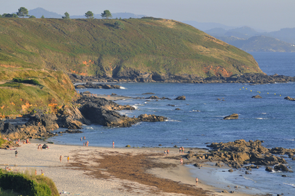
The ria picture is of Ria de Arosa in Spain. As you can see the valley is going in the sea.
A ria is a valley that has been partially submerged by water near a coastline. There may also be other valleys feeding the main valley, forming a treelike pattern of branches. Often, one or more rivers feed the partially submerged valley. Rias that receive fresh water from rivers and streams are also estuaries when they occur on a seacoast, mixing freshwater and saltwater from incoming tides.
A substantial rise in sea level can form a ria. A fall of landmass on a coastline can also permit water to enter a valley and form a ria.
A ria can be from a few hundred feet wide to several miles in width and many miles long. A ria can be equal to the size of the valley that was submerged.
A ria may be found in an region of hills and valleys that descend toward the water as they near the coastline. Hilltops are the last to enter water, looking seaward.
• Narragansett Bay, Rhode Island, USA
• Portsmouth Harbour, England
• Ria de Aveiro, Portugal
• Ria de Arousa, Galicia, Spain
Narragansett Bay on the Atlantic coast of New England is a ria formation of three submerged valleys, the longest which extends north to the cities of Providence and Pawtucket, Rhode Island. The bay is about 10 miles wide with islands that divide portions of the valleys below.
The valleys are grabens that were formed by movement at fault zones in the area, causing parts of the land to drop. Glacier activity also played a major role in carving the land and altering sea levels. Portsmouth Harbour on the southern coast of England is a ria nearly 3 miles wide. It is a natural harbor with a narrow entrance, also protected by the Isle of Wight that lies off the coast.
In addition to protection from heavy seas, it was strategically impossible for an enemy to successfully attack the harbor with guns protecting the entrance from both sides. The Ria de Aveiro is a 28 mile long estuary with many marshland areas. Much of the area has been allowed to remain in its natural state, providing a home for many bird species. The waters are also a popular tourist location and provide excellent fishing opportunities.
Further north, in the Galacia region of Spain on the Atlantic coast, the Ría de Arousa is another estuary with two main rivers providing freshwater. The submergence of several interconnected valleys formed a body of water over 7 miles wide and 14 miles long. The Ría de Arousa is the largest of a series of rias that fill almost the entire west coast of Galicia.
A valley that enters and submerges into a large body of water usually at a coastline.
We want pictures and location of the lanforms around the world and we need your help. Click get started button below.

In Asia, China, India, Nepal, and Bhutan are home to one of the eight wonders of the world and one of the most beautiful mountains in the world, the Himalaya Mountains also called the Himalayas. Boasting as the world’s highest and most famous mountain peak, Mt. Everest. Within the verse of the ‘Kumarsambhava’, Sanskrit […]

Nature have provided us with fascinating landforms and features. The most often adored landforms are volcanoes. Like the perfect cone structure of Mayon Volcano in the Philippines or Mount Fiji in Japan, people look at their beauty and wonder with great appreciation to nature. Volcanoes are mountains with a very disastrous nature. Their only […]

Taal Volcano is the second most active volcano found in the province of Batangas. A complex volcano in the middle of Taal Lake and is often called an island within a lake, that is an island within a lake that is on an island as well as one of the lowest volcano in the […]

Mayon Volcano is one of the active volcanoes in the Philippines. Located in the southern part of Luzon about 473 kilometers (294 miles) from Makati Business District of the Philippines, Mount Mayon is the main landmark of the Province of Albay of Bicol Region. According to local folklore, the volcano was named after Daragang […]

The global temperature and weather is to a large extent a direct result of the sun’s effect to our planet. Together with the atmosphere and the rotation of the earth on its axis. The earth on which weather moves on has its own effect on the weather. The different landforms like mountains, volcanoes, plains, and the […]

