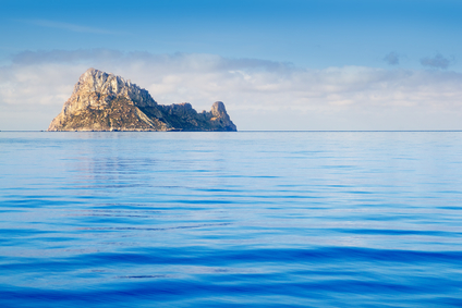
Monchique Islet, Azores Islands
An islet landform is generally considered to be a rock or small island that has little vegetation and cannot sustain human habitation.
An islet may be formed by wave action that can build a sandbar. Volcanic activity can also produce a rock formation above the water to create an islet.
Most islets are only a fraction of one square mile, and are sometimes measured in meters or feet. An islet can be up to several square miles in size. There is no specific rule to determine an islet by size.
Islets can be found on oceans, seas and other large bodies of water. Many are near a coastline, while a few are in the middle of an ocean, hundreds of miles from the nearest land.
• Monchique Islet, Azores Islands
• Fastnet Rock, Cork, Ireland
• South Stack, Anglesey, Wales
• Silver Islet, Ontario, Canada
Monchique Islet is a Portuguese possession that lies off the coast of the Portuguese island of Flores in the Azores Islands of the Atlantic Ocean. Considered to be the westernmost point of Europe, the islet is a rock formation standing 112 feet high, formed by lava flows that produced an irregular shape.
Fastnet Rock, an islet 8 miles off the Irish coast, is farther south than any other point in Ireland. Sometimes called “Ireland’s Teardrop”, it was the last sight of their home country for many Irish people when emigrating to North America during the 19th century.
South Stack is a rocky islet with cliffs high above the water close to Holy Island by the northwest coast of Anglesey, Wales. South Stack Lighthouse is 135 feet tall and the islet is accessible on foot by bridge, bringing thousands of visitors each year.
Silver Islet of Ontario on Lake Superior got its name after a rich vein of silver was discovered there in 1868. At that time, the islet was only about 30 or 40 feet long. A mining company increase the area above water by about 10 times and began extracting silver. Eventually the mine reached a depth of over 1200 feet when most of the silver had been removed. In 1884 the pumps stopped and the mine has been flooded ever since.
A very small island that has little or no vegetation and cannot support human habitation.
We want pictures and location of the lanforms around the world and we need your help. Click get started button below.

In Asia, China, India, Nepal, and Bhutan are home to one of the eight wonders of the world and one of the most beautiful mountains in the world, the Himalaya Mountains also called the Himalayas. Boasting as the world’s highest and most famous mountain peak, Mt. Everest. Within the verse of the ‘Kumarsambhava’, Sanskrit […]

Nature have provided us with fascinating landforms and features. The most often adored landforms are volcanoes. Like the perfect cone structure of Mayon Volcano in the Philippines or Mount Fiji in Japan, people look at their beauty and wonder with great appreciation to nature. Volcanoes are mountains with a very disastrous nature. Their only […]

Taal Volcano is the second most active volcano found in the province of Batangas. A complex volcano in the middle of Taal Lake and is often called an island within a lake, that is an island within a lake that is on an island as well as one of the lowest volcano in the […]

Mayon Volcano is one of the active volcanoes in the Philippines. Located in the southern part of Luzon about 473 kilometers (294 miles) from Makati Business District of the Philippines, Mount Mayon is the main landmark of the Province of Albay of Bicol Region. According to local folklore, the volcano was named after Daragang […]

The global temperature and weather is to a large extent a direct result of the sun’s effect to our planet. Together with the atmosphere and the rotation of the earth on its axis. The earth on which weather moves on has its own effect on the weather. The different landforms like mountains, volcanoes, plains, and the […]

