Example of a Crater Lake Landform:
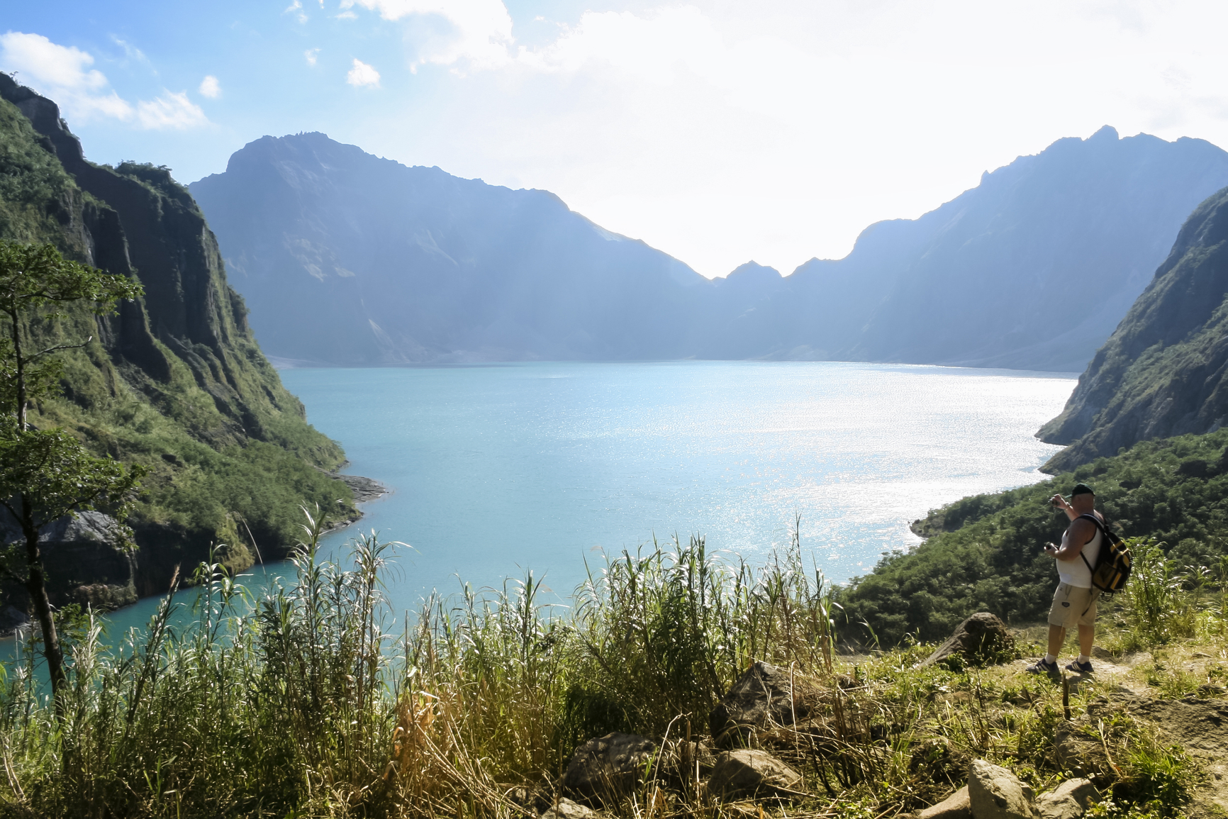
The crater lake picture is of Lake Pinatubo, Philippines.
A crater lake is a depression created by a volcanic crater or caldera that is filled with water.
When a volcano is no longer active, the crater or caldera may fill with water from rainfall and melting snow that may also feed the lake. A caldera is created by the collapse of a volcanic crater and the land around it. In a few cases, the volcano is still active, with vents that release gases under the lake which may cause the water to become acidic and unable to support life.
A lake can also exist in an impact crater, created by the fall of a meteor or in one case a nuclear weapon test in Kazakhstan. Sometimes these are also called crater lakes.
A crater lake is generally one to several miles in diameter.
There are craters and calderas on several continents that have filled with water to form a lake.
Lake Pinatubo, Philippines
Crater Lake, Oregon, USA
Ojos del Salado, Chile
Lake Toba, Indonesia
Manicouagan, Canada
Lake Pinatubo was created after the eruption of Mount Pinatubo in the Philippines on June 15, 1991. A caldera was formed which filled with water to create the deepest lake in the Philippines at 2000 feet. Crater Lake of Oregon has exceptionally clear water fed by rainwater and melting snow and has no drainage. It is the deepest lake in the US at 1949 feet, formed in the caldera of Mount Mazama after an eruption about 7000 years ago. Ojos del Salado in Chile may be the highest lake in the world at 20,965 feet and is 330 feet in diameter. An eruption occurred there around 1300 years ago that may have allowed the lake to form.
Four overlapping volcanic craters form the world’s largest volcanic body of water called Lake Toba in Indonesia. The lake is 62 miles long and 19 miles wide and filled with water after an extremely large volcanic eruption approximately 70,000 years ago.
The Manicouagan Crater of Northern Quebec has multiple rings formed by the impact of a meteor over 200 million years ago. The most prominent ring holds a lake that is 40 miles in diameter and has an island in the middle in the form of a plateau.
A crater or caldera that has filled with water to form a lake
We want pictures and location of the lanforms around the world and we need your help. Click get started button below.

In Asia, China, India, Nepal, and Bhutan are home to one of the eight wonders of the world and one of the most beautiful mountains in the world, the Himalaya Mountains also called the Himalayas. Boasting as the world’s highest and most famous mountain peak, Mt. Everest. Within the verse of the ‘Kumarsambhava’, Sanskrit […]

Nature have provided us with fascinating landforms and features. The most often adored landforms are volcanoes. Like the perfect cone structure of Mayon Volcano in the Philippines or Mount Fiji in Japan, people look at their beauty and wonder with great appreciation to nature. Volcanoes are mountains with a very disastrous nature. Their only […]

Taal Volcano is the second most active volcano found in the province of Batangas. A complex volcano in the middle of Taal Lake and is often called an island within a lake, that is an island within a lake that is on an island as well as one of the lowest volcano in the […]

Mayon Volcano is one of the active volcanoes in the Philippines. Located in the southern part of Luzon about 473 kilometers (294 miles) from Makati Business District of the Philippines, Mount Mayon is the main landmark of the Province of Albay of Bicol Region. According to local folklore, the volcano was named after Daragang […]

The global temperature and weather is to a large extent a direct result of the sun’s effect to our planet. Together with the atmosphere and the rotation of the earth on its axis. The earth on which weather moves on has its own effect on the weather. The different landforms like mountains, volcanoes, plains, and the […]

