Example of a Plateau Landform:
Colorado Plateau, southwestern USA
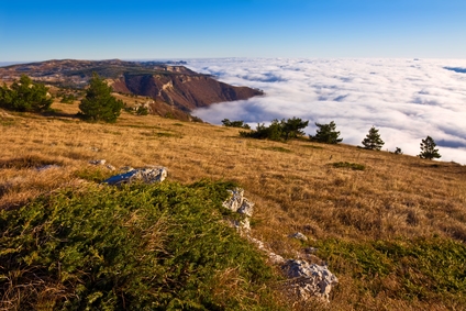
The plateau picture above is of a mountain plateau.
A plateau is a portion of land that is more or less flat and level, elevated above the surrounding area. It may have steep slopes or vertical cliffs on one or more sides.
Plateaus can be formed by the erosion of surrounding areas by rivers, flooding and glacier activity. An uplift of land can occur from the pressure of a large magma chamber under layers of rock. Repeated lava flows can also form a plateau over a period of time. The collision of tectonic plates of the Earth’s crust can elevate a portion of land to create a plateau.
A plateau can cover a few square miles, or extend over an area of thousands of square miles.
Plateaus can be found in some desert areas. The largest plateaus are found near mountainous regions.
• Auyantepui, Venezuela
• Columbian Plateau, northwestern USA
• Colorado Plateau, southwestern USA
• Deoasai Plains, Deosai National Park, Pakistan
• Tibetan Plateau, central Asia
Auyantepui is a tabletop mountain, a plateau in Venezuela with a summit covering 257 square miles. Some areas of the plateau are inclined, reaching from 5,200 to over 8,000 feet. Auyantepui is the source for Angel Falls, the tallest waterfall in the world at 3,212 feet above its base.
The Columbian Plateau covers portions of Washington, Oregon and Idaho in the Pacific Northwest of the US. With a total of 63,000 square miles, it was formed by many basaltic lava flows on the land over millions of years. The Colorado Plateau includes parts of Colorado, New Mexico, Arizona and Utah.
It is the largest plateau in the US, covering approximately 130,000 square miles. It was created by a gradual uplift of the land, while the Colorado River cut through the land to form many canyons below. The Deoasai Plains in northern Pakistan is the second highest plateau in the world.
As part of the Deosai National Park, it has an average height of 13,497 ft and covers 1,200 square miles. The Tibetan Plateau is the highest plateau in the world, averaging almost 15,000 feet, and the largest to be found on any continent. It covers an area of almost one million square miles in central Asia, with the Himalayas in a curve along the southern edge and the Kunlun Mountains to the north.
The plateau is still being formed by tectonic pressure as the Indo-Australian continental plate collides against the Eurasian plate. The plateau is almost entirely within the Tibetan province of China, with a small portion belonging to India.
An area that is raised above other surrounding lands and is generally flat and level.
See plateau’s in the ocean here: Oceanic Plateau
We want pictures and location of the lanforms around the world and we need your help. Click get started button below.

In Asia, China, India, Nepal, and Bhutan are home to one of the eight wonders of the world and one of the most beautiful mountains in the world, the Himalaya Mountains also called the Himalayas. Boasting as the world’s highest and most famous mountain peak, Mt. Everest. Within the verse of the ‘Kumarsambhava’, Sanskrit […]

Nature have provided us with fascinating landforms and features. The most often adored landforms are volcanoes. Like the perfect cone structure of Mayon Volcano in the Philippines or Mount Fiji in Japan, people look at their beauty and wonder with great appreciation to nature. Volcanoes are mountains with a very disastrous nature. Their only […]

Taal Volcano is the second most active volcano found in the province of Batangas. A complex volcano in the middle of Taal Lake and is often called an island within a lake, that is an island within a lake that is on an island as well as one of the lowest volcano in the […]

Mayon Volcano is one of the active volcanoes in the Philippines. Located in the southern part of Luzon about 473 kilometers (294 miles) from Makati Business District of the Philippines, Mount Mayon is the main landmark of the Province of Albay of Bicol Region. According to local folklore, the volcano was named after Daragang […]

The global temperature and weather is to a large extent a direct result of the sun’s effect to our planet. Together with the atmosphere and the rotation of the earth on its axis. The earth on which weather moves on has its own effect on the weather. The different landforms like mountains, volcanoes, plains, and the […]

