Example of a Proglacial Lake Landform:
Lake Missoula, Clark Fork River, Idaho and Montana, USA
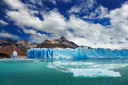
The proglalcial picture is of Perito Moreno Glacier on Argentino Lake in Argentina.
A proglacial lake is a lake that forms behind a moraine or ice dam.
A proglacial lake may form behind a moraine in a valley, left by a retreating glacier. Glacial ice can also create a dam to block the flow of water from a river or melting glacier, forming a proglacial lake. When the dam breaks, catastrophic flooding can occur and carve areas of land downstream.
A proglacial lake can be less than one hundred feet across, or extend for many miles. Lake Missoula was the largest known proglacial lake, covering approximately 3,000 square miles of land.
A proglacial lake may be found in an area of former glacial activity, behind a moraine that blocks the flow of water from higher elevations.
• North-central Wisconsin, USA
• Lake Missoula, Clark Fork River, Idaho and Montana, USA
• Andes Mountains, Peru
• Southern Alps, New Zealand
During the last ice age, a former route of the Wisconsin River in north-central Wisconsin was blocked by a glacier, creating a large proglacial lake. Near the end of the Ice Age, the glacier began to recede. The waters broke through, causing massive flooding that reshaped the land which includes the Wisconsin River Dells.
Lake Missoula was the largest proglacial lake known to exist, created near the end of the last ice age. The Clark Fork River in Idaho was damned by a glacier as many as 40 times during a period of about 2,000 years. Each time, a very large proglacial lake was created that would flood portions of eastern Washington when the dam broke, carving the land.
Some of the glaciers in the Andes Mountains in the tropical latitudes of Peru have receded during the 20th century. They left many moraines, forming proglacial lakes in the mountains. A recently formed moraine can sometimes break, allowing water to flood downhill. In Peru, some of these have been reinforced to prevent flooding and loss of life. In the Southern Alps of New Zealand, several proglacial lakes have formed behind moraines left by retreating glaciers. One is called Lake Tasman where boat tours are now given for visitors. The lake is 4 miles long, over a mile wide and still growing.
A lake formed behind a moraine or ice dam.
We want pictures and location of the lanforms around the world and we need your help. Click get started button below.

In Asia, China, India, Nepal, and Bhutan are home to one of the eight wonders of the world and one of the most beautiful mountains in the world, the Himalaya Mountains also called the Himalayas. Boasting as the world’s highest and most famous mountain peak, Mt. Everest. Within the verse of the ‘Kumarsambhava’, Sanskrit […]

Nature have provided us with fascinating landforms and features. The most often adored landforms are volcanoes. Like the perfect cone structure of Mayon Volcano in the Philippines or Mount Fiji in Japan, people look at their beauty and wonder with great appreciation to nature. Volcanoes are mountains with a very disastrous nature. Their only […]

Taal Volcano is the second most active volcano found in the province of Batangas. A complex volcano in the middle of Taal Lake and is often called an island within a lake, that is an island within a lake that is on an island as well as one of the lowest volcano in the […]

Mayon Volcano is one of the active volcanoes in the Philippines. Located in the southern part of Luzon about 473 kilometers (294 miles) from Makati Business District of the Philippines, Mount Mayon is the main landmark of the Province of Albay of Bicol Region. According to local folklore, the volcano was named after Daragang […]

The global temperature and weather is to a large extent a direct result of the sun’s effect to our planet. Together with the atmosphere and the rotation of the earth on its axis. The earth on which weather moves on has its own effect on the weather. The different landforms like mountains, volcanoes, plains, and the […]

