Example of a Riffle Landform:
Dunn Riffle, Rogue River, Oregon, USA
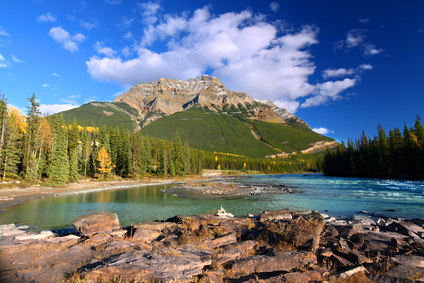
The riffle picture above is of Athabasca River with a view of Mount Kerkeslin at Jasper National Park in Canada.
A riffle is a portion of a river or stream that is shallow with a rough bottom, causing turbulence and forming ripples on the water´s surface.
A riffle is formed by a shallow, rocky bottom in a river or stream. The rocks are not large enough to create large waves or heavy rapids. In very shallow water, a riffle may be formed by a gravel stream bed.
A riffle can extend across the entire width of a river or stream. A riffle may include only a portion of the river´s width.
A riffle can be found in a shallow area of a river or stream where rocks or rock formations may be present on the bottom.
• Dunn Riffle, Rogue River, Oregon, USA
• Green Riffle, Klammath River, Oregon, USA
• Spokane River, Washington State, USA
• Fifty Mile Riffle, Madison River, Montana
• Sandy River, Oregon, USA
Dunn Riffle on the Rogue River near Hellgate Canyon is a favorite fishing spot about 11 miles from the town of Redwood in southwest Oregon. The river is also known for beautiful scenery and excellent whitewater rafting. Green Riffle is a section of the lower Klammath River, upstream of a class 6 rapid called Ishi Pishi Falls with a major drop. If you don´t exit the river at Green Riffle you´ll be in serious danger.
When the river level is high, this rapid is considered impassible. The Spokane River has many riffles that can be found within the city and county of Spokane, a city in eastern Washington State. There is a scenic hiking trail that follows the river for 37 miles, passing through the city of Spokane on the way to the Idaho state border.
Downstream from Yellowstone Park and below Hebgen Dam, Fifty Mile Riffle can be found on the Madison River in Montana. This section of the river has riffles that continue for 50 miles and is known for excellent fly fishing. The Sandy River is a shallow river with many riffles, passing through scenic Oregon country. It enters the Columbia River just east of Portland, Oregon, flowing from its source on Mt. Hood, 56 miles upstream.
A shallow section in a river, creek or stream that causes a ripples in the water.
We want pictures and location of the lanforms around the world and we need your help. Click get started button below.

In Asia, China, India, Nepal, and Bhutan are home to one of the eight wonders of the world and one of the most beautiful mountains in the world, the Himalaya Mountains also called the Himalayas. Boasting as the world’s highest and most famous mountain peak, Mt. Everest. Within the verse of the ‘Kumarsambhava’, Sanskrit […]

Nature have provided us with fascinating landforms and features. The most often adored landforms are volcanoes. Like the perfect cone structure of Mayon Volcano in the Philippines or Mount Fiji in Japan, people look at their beauty and wonder with great appreciation to nature. Volcanoes are mountains with a very disastrous nature. Their only […]

Taal Volcano is the second most active volcano found in the province of Batangas. A complex volcano in the middle of Taal Lake and is often called an island within a lake, that is an island within a lake that is on an island as well as one of the lowest volcano in the […]

Mayon Volcano is one of the active volcanoes in the Philippines. Located in the southern part of Luzon about 473 kilometers (294 miles) from Makati Business District of the Philippines, Mount Mayon is the main landmark of the Province of Albay of Bicol Region. According to local folklore, the volcano was named after Daragang […]

The global temperature and weather is to a large extent a direct result of the sun’s effect to our planet. Together with the atmosphere and the rotation of the earth on its axis. The earth on which weather moves on has its own effect on the weather. The different landforms like mountains, volcanoes, plains, and the […]

