Example of a Rapids Landform:
Lava Falls Rapid, Colorado River, Arizona, USA
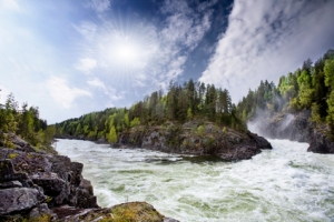
The rapids picture above is of river rapids in Norway.
Rapids are a fast moving portion of a river with rough water.
Water can flow more quickly on a steeper incline. Water passing through a narrow portion of the river can also flow more rapidly. Rapids are also associated with rough water created by rocks and exposed rock layers below the water. Rocks and other obstructions cause water to move more rapidly over and around them.
Rapids can stretch across the entire width of a river, or include only a portion. The length of rapids can be as little as 10 feet, or go on for hundreds of feet. Some rapids can continue for many miles downstream. The size and force of waves and obstructions in rapids are measured according to a scale from 1 to 6. Rapids of class 6 are considered impassible for most people and extremely dangerous.
Many rivers have sections that contain rapids, especially rivers that pass through canyons and mountainous regions.
• Lava Falls Rapid, Colorado River, Arizona, USA
• White Nile River, Uganda
• Inga Rapids, Congo River
• Cotahuasi River, Peru
• Rio Futaleufu, northern Patagonia, Chile
The Colorado River is one of the most famous locations for rafting and kayaking rapids. The most difficult section of the Colorado may be Lava Falls Rapid, a class 5 rapid in the Grand Canyon. The White Nile River of Uganda is a very large river with warm water and many strong rapids recommended by experienced whitewater sportsmen.
The Inga Rapids of the Congo River are considered to be the world’s largest by volume and extremely challenging. For 50 miles, the rapids have four times the volume of the Mississippi, and is one-fifth as wide, having 40 foot whirlpools and waves that can reach 20 feet high.
French adventurer and TV personality Philippe de Dieuleveult with 6 other people disappeared in 1985 while running the Inga Rapids, and were never found. The Cotahuasi River of Peru has many class 4 rapids and several that are rated class 5.
It flows through a canyon that is twice as deep as the Grand Canyon of the Colorado River and has Inca ruins among the spectacular scenery. The Rio Futaleufu of northern Patagonia in Chile is considered one of the best rivers for kayaking. It has the famous class 5 Terminator Rapid with a hole in the middle that must be avoided. The river has unusual turquoise colored waters fed by glacier meltwater flowing through layers of limestone rock.
A section of a river that flows more quickly and has rough water.
See also riffle
We want pictures and location of the lanforms around the world and we need your help. Click get started button below.

In Asia, China, India, Nepal, and Bhutan are home to one of the eight wonders of the world and one of the most beautiful mountains in the world, the Himalaya Mountains also called the Himalayas. Boasting as the world’s highest and most famous mountain peak, Mt. Everest. Within the verse of the ‘Kumarsambhava’, Sanskrit […]

Nature have provided us with fascinating landforms and features. The most often adored landforms are volcanoes. Like the perfect cone structure of Mayon Volcano in the Philippines or Mount Fiji in Japan, people look at their beauty and wonder with great appreciation to nature. Volcanoes are mountains with a very disastrous nature. Their only […]

Taal Volcano is the second most active volcano found in the province of Batangas. A complex volcano in the middle of Taal Lake and is often called an island within a lake, that is an island within a lake that is on an island as well as one of the lowest volcano in the […]

Mayon Volcano is one of the active volcanoes in the Philippines. Located in the southern part of Luzon about 473 kilometers (294 miles) from Makati Business District of the Philippines, Mount Mayon is the main landmark of the Province of Albay of Bicol Region. According to local folklore, the volcano was named after Daragang […]

The global temperature and weather is to a large extent a direct result of the sun’s effect to our planet. Together with the atmosphere and the rotation of the earth on its axis. The earth on which weather moves on has its own effect on the weather. The different landforms like mountains, volcanoes, plains, and the […]

