Example of a River Delta Landform:
Mississippi Delta, Louisiana, USA
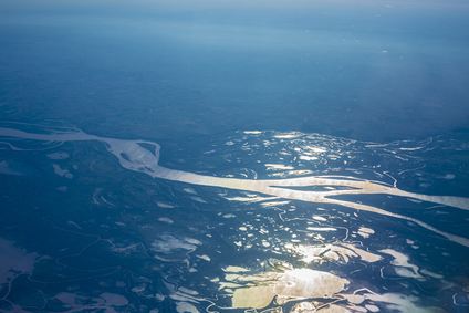
The river delta picture above is of the Parana river delta in Argentina.
A river delta is a section of a river that separates into channels as it enters another body of water.The delta includes the land between channels and the marshlands and other wetlands formed in the area. The Okavango Delta in Botswana is an exception, because it does not enter another body of water. It is a wetland oasis in the desert.
A river delta can form as sediment is carried downstream near the mouth of the river. As this portion of the river becomes more shallow, it can separate into two or more channels forming a river delta over a long period of time. Sediment can also accumulate beyond the mouth of a river and extend channels of a delta further into the sea or other body of water. The rate of flow, the type of sediment and the action of tides can all affect the formation of a delta.
A river delta can cover just a few square miles, or an area of hundreds or thousands of square miles of land.
A river delta may be found where a river enters another body of water. Many rivers don´t have a river delta.
• Mississippi Delta, Louisiana, USA
• Volga Delta, Russia
• Nile Delta, Egypt
• Ganges Delta, India and Bangladesh
The Mississippi Delta is the largest river delta in North America, covering an estimated area of from 10,000 to 13,000 square miles of land according to various sources. About half of this area includes wetlands formed within the delta.
Due to many levees for flood control of the Mississippi, the flow rate has increased, greatly reducing the amount of sediment deposited. The delta region along the coast has lost over 1,800 square miles of wetland areas as a result during the past 80 years. The Volga Delta of Russia enters the Caspian Sea and is the largest river delta in Europe.
The delta has grown to nine times its original size during the last 120 years, now covering over 10,000 square miles of land. The Nile Delta in Egypt extends across an area of from 8,000 to 10,000 square miles of land according to different sources. There are two main channels that now flow from the Nile to the Mediterranean Sea.
In the past, there were several more channels, now lost as flood control reduced the amount of sediment deposited in some areas. The world´s largest river delta is the Ganges Delta, most of which is in the country of Bangladesh. One third of the delta lies in India, and all waters flow into the Bay of Bengal. Sources differ for land coverage of the Ganges Delta, ranging from 23,000 to over 40,000 square miles of land.
Channels of a river entering into another body of water such as an ocean.
We want pictures and location of the lanforms around the world and we need your help. Click get started button below.

In Asia, China, India, Nepal, and Bhutan are home to one of the eight wonders of the world and one of the most beautiful mountains in the world, the Himalaya Mountains also called the Himalayas. Boasting as the world’s highest and most famous mountain peak, Mt. Everest. Within the verse of the ‘Kumarsambhava’, Sanskrit […]

Nature have provided us with fascinating landforms and features. The most often adored landforms are volcanoes. Like the perfect cone structure of Mayon Volcano in the Philippines or Mount Fiji in Japan, people look at their beauty and wonder with great appreciation to nature. Volcanoes are mountains with a very disastrous nature. Their only […]

Taal Volcano is the second most active volcano found in the province of Batangas. A complex volcano in the middle of Taal Lake and is often called an island within a lake, that is an island within a lake that is on an island as well as one of the lowest volcano in the […]

Mayon Volcano is one of the active volcanoes in the Philippines. Located in the southern part of Luzon about 473 kilometers (294 miles) from Makati Business District of the Philippines, Mount Mayon is the main landmark of the Province of Albay of Bicol Region. According to local folklore, the volcano was named after Daragang […]

The global temperature and weather is to a large extent a direct result of the sun’s effect to our planet. Together with the atmosphere and the rotation of the earth on its axis. The earth on which weather moves on has its own effect on the weather. The different landforms like mountains, volcanoes, plains, and the […]

