Example of an Oxbow Lake Landform:
Carter Lake, Nebraska and Iowa, USA
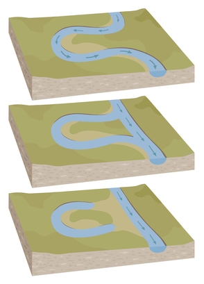
The oxbow lake picture is of a diagram of how it is formed.
An oxbow lake is a long, narrow curved lake. It is a former meander of a river that has been isolated.
When a meander in a river flows near another turn in the river, erosion or flooding may cause the river to break through or cross over the land and form a new channel. A portion of the river is bypassed as water flows through the new channel. Often, sediment will form a new riverbank and isolate the old channel, forming a lake that has a “C” or “U” shape.
The width of an oxbow lake is usually similar to the width of the river that formed the lake. The lake is usually 8 to 20 times longer than its width.
An oxbow lake may be found on a floodplain near a slow moving river with many meanders.
• Carter Lake, Nebraska and Iowa, USA
• Cuckmere River, Sussex, England
• Connecticut River, Northampton, Massachusetts, USA
• Lake Chicot, Arkansas, USA
• Kanwar Taal Lake, Begusarai, Bihar
Carter Lake on the border of Nebraska and Iowa was formerly known as the Saratoga Bend of the Missouri River. During a flood in 1877, the river formed a new channel and Saratoga Bend became an oxbow lake.
The meandering Cuckmere River on the floodplain of Sussex, England has formed several oxbow lakes on its way to the English Channel. As a popular tourist destination, the river enters the channel by the Seven Sisters, famous white chalk cliffs overlooking the Channel.
A lake called The Oxbow was formerly part of the Connecticut River in Northampton, Massachusetts. A flood in 1840 cut a new channel and the meander formed an anabranch, which remained connected to the river at both ends. It was then used by a logging company as a holding area for logs floated downstream.
Later, the northern end was filled during construction of the Interstate 91 Expressway, forming an oxbow lake attached to the river at the south end. The largest oxbow lake found in North America is Lake Chicot of Arkansas. It was formed 600 years ago by the Mississippi River and is over 21 miles long and 3/4 mile wide.
Kanwar Taal Lake of Bihar is the largest oxbow lake in Asia with freshwater. This is the location of the Bharatpur Bird Sanctuary in Keoladeo National Park, supporting over 230 bird species.
A long, curved lake that is a former meander of a river.
We want pictures and location of the lanforms around the world and we need your help. Click get started button below.

In Asia, China, India, Nepal, and Bhutan are home to one of the eight wonders of the world and one of the most beautiful mountains in the world, the Himalaya Mountains also called the Himalayas. Boasting as the world’s highest and most famous mountain peak, Mt. Everest. Within the verse of the ‘Kumarsambhava’, Sanskrit […]

Nature have provided us with fascinating landforms and features. The most often adored landforms are volcanoes. Like the perfect cone structure of Mayon Volcano in the Philippines or Mount Fiji in Japan, people look at their beauty and wonder with great appreciation to nature. Volcanoes are mountains with a very disastrous nature. Their only […]

Taal Volcano is the second most active volcano found in the province of Batangas. A complex volcano in the middle of Taal Lake and is often called an island within a lake, that is an island within a lake that is on an island as well as one of the lowest volcano in the […]

Mayon Volcano is one of the active volcanoes in the Philippines. Located in the southern part of Luzon about 473 kilometers (294 miles) from Makati Business District of the Philippines, Mount Mayon is the main landmark of the Province of Albay of Bicol Region. According to local folklore, the volcano was named after Daragang […]

The global temperature and weather is to a large extent a direct result of the sun’s effect to our planet. Together with the atmosphere and the rotation of the earth on its axis. The earth on which weather moves on has its own effect on the weather. The different landforms like mountains, volcanoes, plains, and the […]

