Example of a Pit Crater Landform:
Halemaʻumaʻu Crater, Mt. Kīlauea, Hawaii, USA
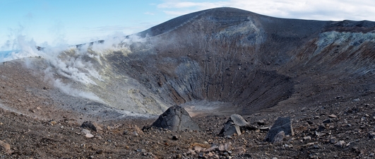
The pit crater picture above is of Grand Crater on Volcano Island near Sicily.
A pit crater is an hole in the ground with vertical or steep sides in an area of volcanic activity. There is usually no elevated portion around the crater.
A pit crater is usually formed by the collapse of ground above an empty space, such as a lava tube or former magma chamber. The ground around a pit crater may overhang part of the hole when a pit crater has recently formed. As time goes on, the ground above may collapse to form vertical sides.
A pit crater can also be created by the explosion of a magma chamber close to the ground surface. A pit crater is not be formed by a volcanic eruption.
A pit crater can be from a few feet wide to several thousand feet in diameter. The depth can reach hundreds of feet below the surrounding area.
Pit craters are common in areas of volcanic activity like volcanoes, or where it has occured in the past.
• Halemaʻumaʻu Crater, Mt. Kīlauea, Hawaii, USA
• Puhia Pele and Luamakami craters, Island of Hualālai, Hawaii, USA
• Los Gemelos, Santa Cruz Island, Galapagos Islands
• Island of Ischia
• Darvaza Gas Crater, Karakum Desert, Turkmenistan
The caldera at the summit of Mt. Kīlauea on the Island of Hawaii is over 2 miles in diameter. It has a very large pit crater called Halemaʻumaʻu that measures over 3,000 feet across and 279 feet deep. The Island of Hualālai, also one of the Hawaiian Islands, has many pit craters.
Puhia Pele and Luamakami craters reach more than 800 feet in depth. Santa Cruz Island of the Galapagos Islands has 2 large pit craters called Los Gemelos, “The Twins”. The largest is nearly 1,300 feet across and 2,300 feet deep. Magma and volcanic gases created pressure to form large underground caverns that later collapsed to form pit craters.
Near the coast of Italy, west of the Gulf of Napoli, the Island of Ischia has many active volcanic vents. A very large lava dome was created at a height of about 1,100 feet. A pit crater later formed at its summit that is over 1,200 feet wide and almost 400 feet deep. The Darvaza pit crater in the Karakum Desert of Turkmenistan is called a gas crater. Local people call it “The Door to Hell”.
During a drilling operation in the search for oil, the ground collapsed under the equipment, causing a collapse of the area to expose a large void below. Several pit craters formed, with natural gas escaping from below. An attempt was made to remove the gas by setting it on fire, hoping it would all burn away. The largest pit crater, 230 feet wide, has been burning continuously now since 1971.
A hole in the ground formed by an underground void and collapse of the ground above, in an area of volcanic activity.
We want pictures and location of the lanforms around the world and we need your help. Click get started button below.

In Asia, China, India, Nepal, and Bhutan are home to one of the eight wonders of the world and one of the most beautiful mountains in the world, the Himalaya Mountains also called the Himalayas. Boasting as the world’s highest and most famous mountain peak, Mt. Everest. Within the verse of the ‘Kumarsambhava’, Sanskrit […]

Nature have provided us with fascinating landforms and features. The most often adored landforms are volcanoes. Like the perfect cone structure of Mayon Volcano in the Philippines or Mount Fiji in Japan, people look at their beauty and wonder with great appreciation to nature. Volcanoes are mountains with a very disastrous nature. Their only […]

Taal Volcano is the second most active volcano found in the province of Batangas. A complex volcano in the middle of Taal Lake and is often called an island within a lake, that is an island within a lake that is on an island as well as one of the lowest volcano in the […]

Mayon Volcano is one of the active volcanoes in the Philippines. Located in the southern part of Luzon about 473 kilometers (294 miles) from Makati Business District of the Philippines, Mount Mayon is the main landmark of the Province of Albay of Bicol Region. According to local folklore, the volcano was named after Daragang […]

The global temperature and weather is to a large extent a direct result of the sun’s effect to our planet. Together with the atmosphere and the rotation of the earth on its axis. The earth on which weather moves on has its own effect on the weather. The different landforms like mountains, volcanoes, plains, and the […]

