Example of a Terrace Landform:
Pacific Coast, Fort Bragg, California, USA
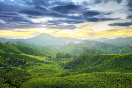
The terrace picture above is of a tea plantation in Cameron Highlands, Malaysia.
A terrace is a raised portion of land that is flat or nearly flat and level above a shoreline, valley, or plain. A marine terrace overlooks an ocean or sea.
A terrace can be formed as a river cuts deeper into the land. A new, lower floodplain may then be established, leaving part of the former flood plain at a higher level as a terrace. A marine terrace, or raised beach, can be formed above an ocean shore when a former beach is elevated by an uplift of the land, or there is a drop in sea level.
A glacier can sometimes form a terrace when running streams of meltwater cut into the mountainside. Glacial lakes have also created narrow terraces, remaining in the hillside when the water is gone.
A terrace can be from a few feet wide to the size of a beach. A large terrace may be part of a plateau that extends for hundreds of square miles.
A terrace can be found above an ocean shore or on the border of a floodplain. A terrace can be found in desert areas where a former body of water existed. Terrace formations may overlook a valley where there was glacier activity in the past.
• Pacific Coast, Fort Bragg, California, USA
• San Diego, California, USA
• Table Cape, Māhia Peninsula, New Zealand
• Island of Curaçao, Antilles Islands
• Grand Staircase, Arizona and Utah, USA
The San Andreas Fault was the subject of a study on the California coast for 15 miles of the coastline near Fort Bragg. The land has uplifted approximately 1 1/2 feet every one thousand years and there are three different terrace formations at different heights.
The San Diego area of the southern California coast has been found to have 16 different terrace levels, many now eroded. These may indicate many past changes in sea level and land elevation. Table Cape on the Māhia Peninsula of New Zealand has experienced many earthquakes during its past. These are said to have caused an uplift and tilt of the land, forming a sloping marine terrace overlooking the sea.
The Island of Curaçao in the Netherlands Antilles has four limestone terraces on the north coast from 25,000 years to 1.5 million year old. Each terrace contains remnants of coral, having once been part of a coral reef below the water. A series of terraces called the Grand Staircase begin from the northern rim of the Grand Canyon to the Paunsaugunt Plateau in Southern Utah.
These include cliffs up to 2000 feet high and terraces up to 15 miles wide. It was created by the action of rivers and inland seas that have existed at various times in the past at different elevations.
An elevated portion of land that is generally flat and level, overlooking a shoreline, valley or plain.
We want pictures and location of the lanforms around the world and we need your help. Click get started button below.

In Asia, China, India, Nepal, and Bhutan are home to one of the eight wonders of the world and one of the most beautiful mountains in the world, the Himalaya Mountains also called the Himalayas. Boasting as the world’s highest and most famous mountain peak, Mt. Everest. Within the verse of the ‘Kumarsambhava’, Sanskrit […]

Nature have provided us with fascinating landforms and features. The most often adored landforms are volcanoes. Like the perfect cone structure of Mayon Volcano in the Philippines or Mount Fiji in Japan, people look at their beauty and wonder with great appreciation to nature. Volcanoes are mountains with a very disastrous nature. Their only […]

Taal Volcano is the second most active volcano found in the province of Batangas. A complex volcano in the middle of Taal Lake and is often called an island within a lake, that is an island within a lake that is on an island as well as one of the lowest volcano in the […]

Mayon Volcano is one of the active volcanoes in the Philippines. Located in the southern part of Luzon about 473 kilometers (294 miles) from Makati Business District of the Philippines, Mount Mayon is the main landmark of the Province of Albay of Bicol Region. According to local folklore, the volcano was named after Daragang […]

The global temperature and weather is to a large extent a direct result of the sun’s effect to our planet. Together with the atmosphere and the rotation of the earth on its axis. The earth on which weather moves on has its own effect on the weather. The different landforms like mountains, volcanoes, plains, and the […]

